
For months we all asked the “when does El Niño start” questions only to now hear he might now be on the downslide. At least that’s the word from recent NASA predictions and satellite readings that show the Pacific’s sea surface temps are starting to cool. But in no way is NASA saying the storms, the waves, the snow and other extreme weather patterns are going to slow down anytime soon.
In asking “when does El Niño start” and “when will El Niño end” the general public is typically referring to the most noticeable storms and weather events that directly and obviously impact us. With that said, we also know El Niño was hard at work long before the madness that kicked off 2016. So in that same context even if NASA’s latest prediction is true we will still see our fair share of waves and snow for months to come.
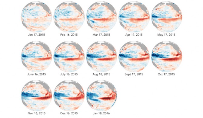
12-month readings from NASA’s Jason-2 satellite.
NASA’s Jason-2 satellite has been monitoring sea surface changes over the Pacific for months, specifically looking for fluctuations in surface heights which correlate with warmer water. Coupled with the idea that this El Niño mirrors many of the patterns we saw during 1997-98, NASA believes the Pacific ocean will finally start to cool off and bring things back to normal…maybe. As the NOAA said in its weekly El Niño report, “will the ocean respond in 2016 the way it did in 1998 and 1983? Given that the planet is hotter than at any time in the past 135 years, there are no guarantees.”
Since 2015 was Earth’s hottest on record NOAA says NASA’s estimation that El Niño may be starting its downturn doesn’t necessarily mean the event will behave as expected. NOAA does still predict El Niño-like activity to temper in spring but like they said, “there are no guarantees.” Even if this is the beginning of the end for El Niño we still have plenty of storms, waves and snow left.
