
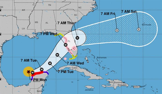
The hurricane should make landfall Wednesday night. Image: NOAA
In just 28 hours, Hurricane Milton strengthened from a tropical storm to a category 5 hurricane with maximum sustained winds clocked at 160 miles per hour. The storm is currently skirting the coast of Mexico’s Yucatan peninsula before it makes a predicted turn to the northeast and barrels straight toward Florida’s west coast.
Evacuations have begun in Florida as the storm is expected to make landfall Wednesday evening near the densely populated area of Tampa Bay, which is still recovering from damage caused by Hurricane Helene less than two weeks ago. Six million people have been placed under hurricane watch in west and central Florida.
While Milton is expected to lose strength as it approaches the Florida coast, current models still predict that its winds could remain at hurricane force even as it crosses the Florida peninsula into the Atlantic Ocean. The storm surge in western Florida could reach as high as 10 to 15 feet in addition to five to 10 inches of rain that will fall.
As of Monday morning, the storm is situated 720 miles southeast of Tampa Bay moving at a speed of nine miles per hour.
Milton is now the second hurricane of the season to reach category 5 status (the highest classification of a hurricane’s strength) after Beryl also broke the 157-mile-per-hour threshold earlier this year in July.
As millions brace for the impact of Milton, surfers are keeping a close eye on the forecast for the incoming swell. Due to the counterclockwise storm rotation, areas north of the landfall will see offshore winds that could create ideal surf conditions. Areas south of the landfall zone will see heavy onshore winds and receive the brunt of the storm surge.
