California just saw August snow for the first time in 20 years. We are in the first week of September and Canada, Montana, Wyoming, and Colorado have also joined the club. Granted, nobody is celebrating season-opening snowfall but even a little dust at high elevations can be enough to get powder hounds in the mood for an upcoming winter.
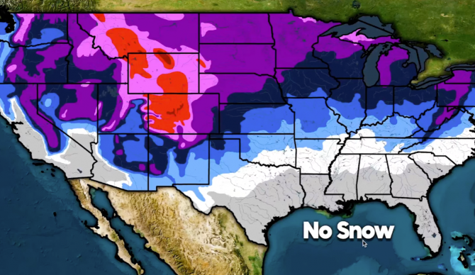
How do these recent storms measure up against history though? With another La Niña winter developing and the endless curveballs that pattern can throw at forecasters, the YouTube channel Direct Weather looked at historical averages to break down when different parts of North America can typically expect the first snowfall.
Based on their data, Central Colorado, Northern Wyoming, and Southern Montana typically all see first snows at some point this month. Next up comes Southern Wyoming and the Teton Range and the Rockies across Montana and Colorado. By late October, Mt. Hood, the Cascades, and the Wasatch Range can expect the first snowfall while Upstate New York, parts of Vermont, parts of New Hampshire, and parts of Maine all get into the mix out East. Early November is when the Sierra Nevada mountains typically start to see snow. Nevada, Central and Northern Idaho, North and South Dakota, areas around the Great Lakes, and the Appalachian Mountains should also start to see snow by this point as well.
By late November and the last month of the fall season, the holidays are in full swing and everybody in North America is either in a very early-season routine or thirsting for an Opening Day.
Hopefully, yours comes around early this winter.


