
Image: NOAA
The National Oceanic and Atmospheric Administration (NOAA) began an official “El Niño watch” in early April, alerting the world that the ocassional weather phenomenon may be coming right on the heels of three consecutive La Niña winters — a “triple dip.” Actually, to be more specific, they told us a “Super El Niño” was likely on its way, which somehow felt appropriate following a winter that made the words atmospheric river a part of our regular vocabulary.
“The really big ones reverberate all over the planet with extreme droughts, floods, heatwaves, and storms,” NOAA’s Dr. Mike McPhaden said at the time. “If it happens, we’ll need to buckle up. It could also fizzle out. We should be watchful and prepared either way.”
After just two months of monthly El Niño watch updates the administration says El Niño is here. Not developing, not possibly coming, but here. It’s a noteworthy development because even when they sounded those first bells in April the expectation was for conditions to develop from May to July and El Niño likely in full swing by the fall months.
“Today we’re hoisting an El Niño Watch, meaning that conditions are favorable for the development of El Niño conditions within the next 6 months,” they wrote in April.
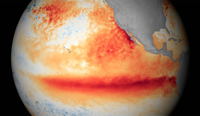
On Thursday, they announced it’s here. “El Niño conditions have developed, as the atmospheric response to the warmer-than-average tropical Pacific sea surface kicked in over the past month,” they say. “We expect El Niño to continue into the winter, and the odds of it becoming a strong event at its peak are pretty good, at 56%. Chances of at least a moderate event are about 84%.”A video animation published the same day detailed El Niño conditions — a three-part process that begins with the warming of sea surface temperatures around the equatorial Pacific and is cemented with atmospheric changes in response — began in January as the La Niña winter was preparing to wind down.
So what does this all mean? There’s still a range of outcomes for the next several months, from a moderate El Niño to the Super El Niño NOAA forecasters first rang the alarm for. The typical El Niño arrives in late sumer-early fall. But the early arrival of this event gives it “room to grow,” as forecasters put it, setting the expecation for a stronger event that will last through the coming winter. El Niño typically creates a stronger hurricane season over the Pacific with a weaker hurricane season over the Atlantic. The Pacific Northwest and midwest regions of the U.S. and Rockies tend to see drier, warmer winters. Meanwhile, the Southwest usually sees colder and wetter winters. However, NOAA forecasters are clear to say that even a strong El Niño doesn’t guarentee any of those conditions, they simply tend to be associated with one another
“Nature always has surprises in store, and predicting anything several months in advance is difficult,” says Emily Becker, lead writer for the NOAA’s ENSO blog. “While El Niño conditions have developed, there’s still a small chance (4-7%) that things will fizzle out. Clearly, we think this is unlikely, but it’s not impossible. The incredible warmth of the global oceans could throw us a curveball, since we’ve not seen this before. Another potential, but also less likely, outcome is a weak El Niño, with about a 12% chance.”

Climate.gov
