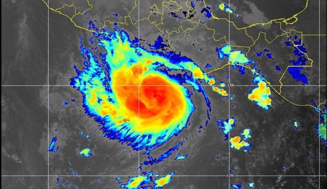
Hurricane Otis went from a tropical storm to a Category 5 hurricane in under 12 hours. Image: NOAA NWS National Hurricane Center
Early on Wednesday morning, Hurricane Otis made landfall just outside of Acapulco, Mexico. It hit with a pile of force — maximum sustained winds of 165 mph with higher gusts — after morphing from a boring old tropical storm into a full-fledged Category 5 storm in less than 24 hours.
As Otis bore down on Mexico, forecasters urged caution, saying that catastrophic damage was likely. They didn’t realize just how bad it would be until only a few hours before it hit. “A nightmare scenario is unfolding,” the National Hurricane Center said late Tuesday evening. Later on, they warned of of “life-threatening winds and a catastrophic storm surge.”
As the day dawned on Wednesday, the damage became obvious. Power was out in many areas, buildings were destroyed, and flooding was reported all over the Acapulco metropolitan area. As Otis heads inland, however, it is losing strength amid the mountains.
According to reports, Otis’ rate of intensification in a 12-hour period was record-breaking. Warming seas and air temperatures are to blame, as hurricanes rely on warm water to exist. As the world warms, storms are increasing in strength and frequency.
“Warmer ocean and air temperatures allow the air to carry more moisture, which is fuel for these storms,” wrote Axios. “If the conditions are right, they can take off and jump storm categories in a matter of hours.”
As of this writing, nearly all communications in Acapulco have been knocked offline. The area is not only a popular tourist destination, but home to around 800,000 people. Otis slammed into the coastline at just after midnight on Wednesday morning, and although there haven’t been any casualties reported so far, the situation is still murky. What is known, however, is that the damage is extensive. Roads are blocked by landslides and flooding is apparent.
Guerrero Gov. Evelyn Salgado Pineda announced Wednesday morning temporary shelters were open in Tecpan de Galeana, Coyuca de Benítez, and Acapulco.

