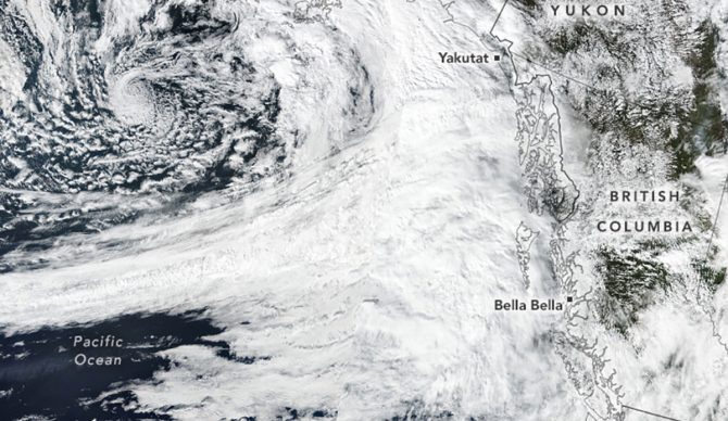
Experts suspect this atmospheric river was among the most intense to transit the northeast Pacific since 2000. Photo: NASA
Parts of the US and much of Canada experienced a soggy September. That alone is not far from the norm, but the amount of precipitation, once all was said and done, was far more than normal. Now, researchers suspect it was because an atmospheric river was one of the most world’s most intense in over two decades.
Atmospheric rivers, for those unacquainted, are bands of moisture in the sky that can be likened to rivers in the sky. They’re made up of condensed water vapor and can be over 1,000 miles long. When they hit a landmass, the vapor rapidly cools down and turns into rain or snow. Generally, they’re just part of the normal climate cycles, but when they get huge, they can have devastating effects.
A few years ago, researchers decided that they needed some type of scale to properly measure atmospheric rivers. Since they vary wildly in terms of intensity and duration, the researchers developed a scale similar to the Fujita scale used for tornadoes.
“The storm shown here [September 24] made landfall as a Category 5 atmospheric river—the highest tier on the scale—near Bella Bella and at progressively lower intensities to the north and south,” NASA’s Earth Observatory wrote. “Prior to making landfall, the system’s overall intensity was much higher.”
The most rain fell in the the Coast and Hazelton Mountains and Glacier Bay National Park — rainy areas in the fall as it is — but this September was even wetter than usual.
“When it made landfall, this particular atmospheric river was what’s known as a Category 4 or 5 – 5 being the highest category there is,” NASA continued. “Category 5s are also known as ‘exceptional’ and are considered to be primarily hazardous rather than beneficial – meaning that they could come hand in hand with flood risk.”
The reasons behind why this particular atmospheric river was so powerful likely have to do with a change to the Arctic Oscillation climate pattern. It’s rare to see in September, and it’s a good bet that those changes added fuel to the fire.

